11 Amazing Places to See Along the Washington Coast
Rugged, remote, and wild, the Washington Coast exceeds expectations with every mile you head north along U.S. Route 101—from the mouth of the Columbia River to the tip of the Olympic Peninsula. Known for its lack of amenities, there are only a few small towns scattered along the way, leaving you alone with the elements, able to experience solitude, serenity, and the intensely gorgeous scenery along the shores of the Evergreen State. While a lifetime could easily be spent uncovering every isolated nook and cranny along the Washington Coast, the following 11 destinations will whet your appetite and provide a great taste of what this gorgeous strip of coastal paradise has to offer.
1. Cape Disappointment

Located at the northern mouth of the Columbia River, Cape Disappointment offers excellent views of enormous waves slamming against rocks, while a picturesque lighthouse rests above. Cape Disappointment is one of Washington’s State Parks, offering eight miles of hiking trails and a campground complete with yurts, RV and tent sites. Said to be one of the foggiest places in the Unites States, the cape and its trails are amazing during the winter months, as giant storm surges transform the area into a chaotic and beautiful coastal wonderland.
2. Long Beach

Stretching for 28 miles, Long Beach Washington claims to be the longest beach in the United States and is said to be the second longest drivable beach in the world. With sand dunes and driftwood, museums, kite flying and gorgeous sunsets, Long Beach is the perfect place to go and relax along the Pacific Coast. Surrounded by Wildlife Refuges and State Parks, this remote corner of Washington State will give you privacy and solitude along the cresting waves. Whether you decide to stop at Marsh’s Free Museum and see Jake the Alligator man, or wander the beach in search of agates and prettified wood, Long Beach is worth the drive off of Highway 101.
3. Westport

On the southern side of Grays Harbor, the small town of Westport sits along the coast, protected from the mighty Pacific by a man-made rock jetty. Known for incredible fishing, breathtaking sunsets, and a rich seafaring culture, Westport offers an historical glimpse at life along the Washington Coast. Small shops line the boardwalk, while local parks give you access to miles of walking along the windswept dunes. Most of the year, the fishing out of Westport is incredible, helping anglers land salmon, albacore tuna, and halibut. In the spring, whale watching trips are available to watch the 20,000+ gray whales swim north, less than a mile offshore.
4. Damon Point

Across Grays Harbor from Westport, Damon Point rests at the end of the Ocean Shores Peninsula, giving incredible views of the entire region. As the Olympic Mountains and Mount Rainier rise up to the east, the mighty Pacific extends to the horizon to the west, allowing a breathtaking vista under soaring bald eagles. Damon Point is a great stop for beach combers, giving miles of beaches to walk while looking for agates, petrified wood, and anything else washing up on the shore. With seals commonly seen offshore and the occasional snowy owl in the winter, wildlife watching makes for another great reason to visit this off-the-beaten-path destination.
5. Kalaloch Tree Root Cave

Once you enter Kalaloch, where the rainforest meets the ocean and where sea stacks slowly decompose into the never-ending onslaught of waves, the true rugged beauty of the Washington Coast begins to take hold. One of the more scenic views, aside from the breathtaking vista at the Kalaloch Lodge, is the Kalaloch Tree Root Cave, just a few hundred feet from the campground parking lot. Defying the odds, this tree is holding on by its roots, surviving against the power of erosion and the elements. Struggling and somehow living another day, we are inspired by its resilience, strength, and beauty.
6. Ruby Beach

Just a few miles north of Kalaloch Lodge on Highway 101, one of the most spectacular beaches on the entire west coast is waiting to be discovered. Full of sea stacks and driftwood, incredible views and bloody sunsets, Ruby Beach is one of the most impressive and accessible coastal areas in the National Park Service. Getting to this beach requires a short 1/2 mile walk down a well-maintained trail from the parking area to the beach itself. Here, numerous sea stacks rise up from the ground, most noticeably the large island to the north called Abbey Island. To the west, Destruction Island rests offshore, home to a lighthouse visible from the beach. The beach is gorgeous and offers the perfect introduction to the 73 miles of wilderness coast in Olympic National Park.
7. Second Beach

One of the classic coastal hikes of Olympic National Park, Second Beach can be found west of Forks, near the small tribal town of LaPush. At just four miles round trip, the hike to Second Beach leaves most hikers breathless with the incredible views of sea stacks, pounding surf, tide pools, and wildlife sightings. During low tide, one can walk south for nearly a mile, finding solitude even on busy summer days. Highlighted by the arch stretching to the north and the Quileute Needles offshore, this is an ideal place to relax, set up camp, and watch a spectacular sunset. This is one of the most scenic places in Washington and worth the detour.
8. Rialto Beach

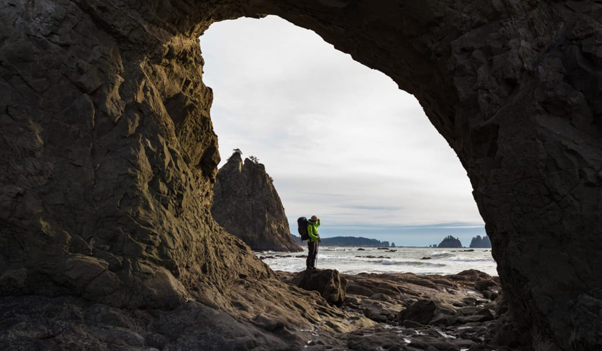
North of the Quileute River and the small town of LaPush, Rialto Beach is one of the most well-known Olympic National Park beaches. Highlighted by the hike to Hole in the Wall, which is two miles north of the trailhead, this remote and rugged hike is incredibly popular. Hole in the Wall is a bus-sized hole in a sea stack, surrounded by tide pools and incredible sea stacks in all directions. This is typically the first stretch of multi-day backpacking trips along the Olympic Coast and has plenty of opportunities to see eagles, sea otters, seals, and even whales. With magnificent sunsets and the steady sound of the crashing waves pushing tons of rocks with each churn, this is an ideal place to relax and forget about the problems of the world.
9. Ozette Triangle

Yet another iconic hike, the Ozette Triangle is remote, wild, and absolutely gorgeous. Far from any city, the journey to get to Ozette seems to take just about as long as it does to hike the nine mile loop trail. The trail is broken up into three sections: the initial boardwalk, the beach, and the return boardwalk. Each is about three miles in length and pretty easy to follow. While the boardwalks are neat, the draw to the region is the three miles of gorgeous coast. For most, the highlight of the coastal section is found halfway along the beach. Here, a small trail is visible, leading to a sea stack known as Wedding Rocks. The area is stunning and is a site of ancient petroglyphs, depicting timeless scenes of coastal beauty. While best done as a backpacking trip, Ozette can be hiked in a day and is one of the classic adventures in Olympic National Park.
10. Shi Shi Beach

While Ozette gets most of the fame, Shi Shi Beach is considered by many to be the best stretch of coast in Washington State. Accessed from the Makah Reservation near the very northwest corner of the Olympic Peninsula, the eight mile round trip trek to Shi Shi Beach and Point of the Arches is a geological coastal wonder, offering unique sea stacks, incredible rock formations, and fantastic tide pools overflowing with life. The first three miles of the trail can be muddy, as they work their way south on the bluff, but the slog is worth every step once you reach the spectacular scenes awaiting you at the coast. Point of the Arches has some of the best sunsets in America and has been frequently featured in nature and photography magazines for its incredible beauty. Do not miss this beach.
11. Cape Flattery

Finally, no trip along the Washington Coast is complete without standing on the northwestern-most point in the contiguous United States. Known as Cape Flattery, this trail and viewpoint located on the Makah Reservation is downright breathtaking. Following the trail, which is just 1.5 miles in length, experience the majesty of coastal forests while walking over cedar-planked raised walkways. The short path leads to one of the most-rugged and beautiful overlooks in America, giving you a glimpse of pure Pacific Northwest beauty. As sea stacks with trees rise from the swelling sea below, seals and seal lions play in the surf. Off the coast, whales are frequently spotted swimming where the Pacific Ocean meets the Strait of Juan de Fuca. Few places in America are as remote and inspiring as Cape Flattery. As you stand on the edge of the country, gazing out into the blue horizon, the spirit of the Pacific Northwest can be felt in full force.
More information these and other destinations long the Washington Coast can be found in the author’s guidebook, the Definitive Guide to Olympic National Park and Peninsula.


![Frontier Ultralight One Pot Cook Set - [3 Piece]](http://seatosummit.com.au/cdn/shop/files/FrontierULOnePotCookSet1P3Piece1.3LPotWithS-BowlandCup_ACK027031-122114_PRIMARY-1200x1200-9c6bd91.jpg?v=1749433473&width=900)
![Frontier Ultralight One Pot Cook Set - [3 Piece]](http://seatosummit.com.au/cdn/shop/files/FrontierULOnePotCookSet1P3Piece1.3LPotWithS-BowlandCup_ACK027031-122114_ADDITIONAL_1-1200x1200-9c6bd91.jpg?v=1749433473&width=900)
